
At the head of the Aosta Valley the road narrows, the last vineyards fall away, and Mont Blanc closes the horizon in a wall of rock and ice. Courmayeur sits where Italy runs out, the last town before the mountain, a street of shops at its center and the highest ground in the Alps standing over its roofs. It has spent two centuries learning to live in that company. In the late afternoon the light comes off the glaciers pale and even, and the two torrents that gather below the town carry the sound of meltwater down toward Aosta. In summer the shops give way quickly to footpaths, and most of what there is to do in Courmayeur begins where the pavement ends.
In this article
The history of Courmayeur and its mountain guides
Courmayeur history begins with its position. The town lies at roughly 1,224 meters at the head of the Aosta Valley, the smallest and least populous region in Italy, autonomous and officially bilingual in Italian and French, where a Franco-Provençal patois, the patois valdôtain, is still spoken in the villages. Above it stands Mont Blanc at just over 4,800 meters the highest peak in the Alps and in western Europe. Its ice cap is remeasured every two years and shifts by a meter or so between surveys; the 2023 measurement put the summit at 4,805.59 meters. Two side valleys flank the town, Val Ferret to the east and Val Veny to the west, and between them the Dora collects and runs.
Mont Blanc and Monte Bianco are the same name in two languages, the French and the Italian of the massif, both saying plainly what the mountain is: the white mountain. It has two sides, and they happen to speak those two tongues. Courmayeur holds the Italian face, Chamonix the French, and since 1965 the Mont Blanc Tunnel has joined them beneath some eleven kilometers of rock. The contrast survives the tunnel. Chamonix is a town organized around the spectacle of the mountain, busy and vertical; Courmayeur is quieter and more inward, a place that looks up at Mont Blanc rather than out from it. Much of what follows comes from that difference in temperament.
The water came before the tourism. The sulphurous springs down the valley at Pré-Saint-Didier were known in Roman times and taken in earnest from the seventeenth century onward, and through the nineteenth Courmayeur grew as a spa and climbing resort, drawing the aristocracy of Turin and the House of Savoy to its mineral waters. That same century turned the town into a base for the golden age of alpinism on the Italian side of the massif, and the two vocations, the cure and the climb, have shared it ever since.
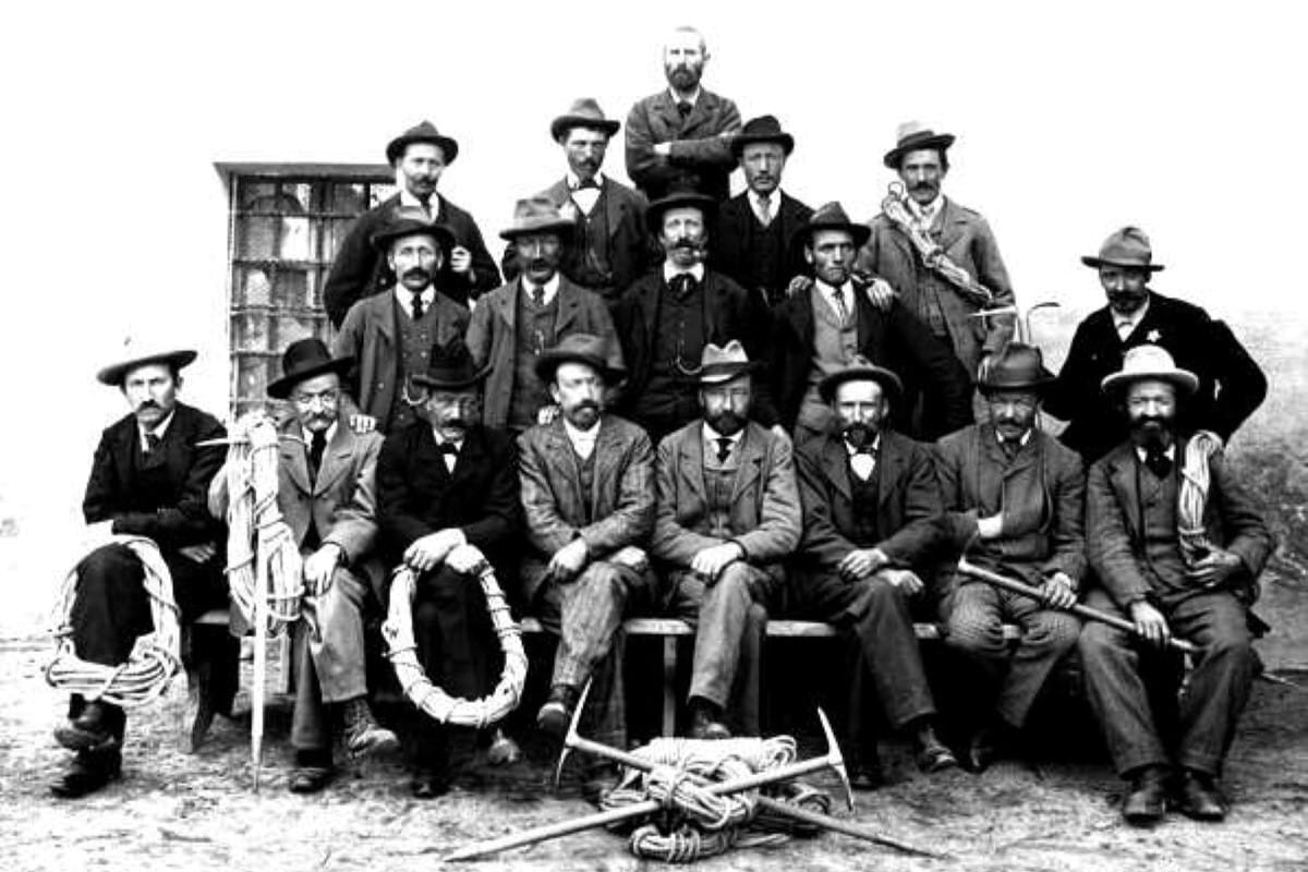
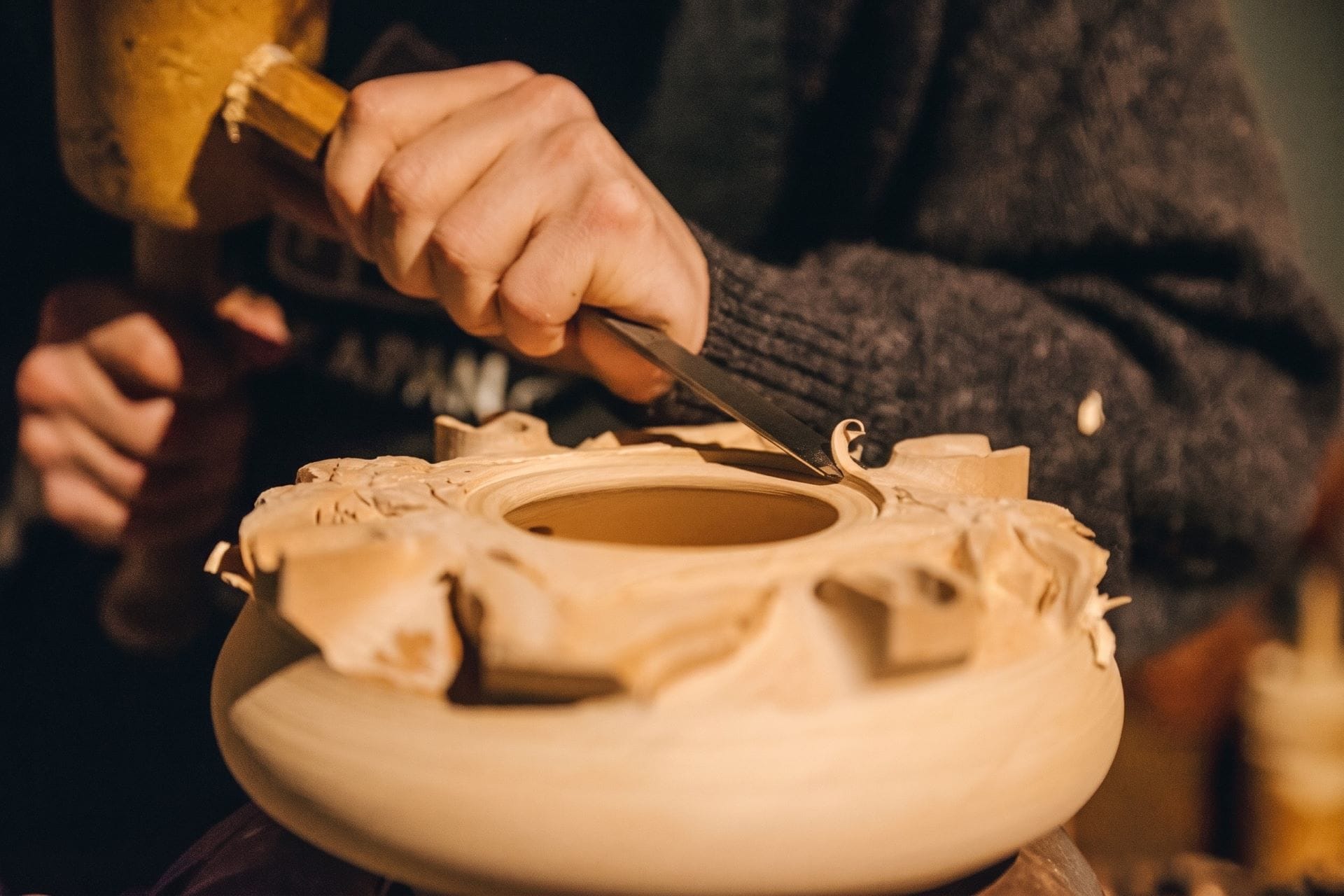
In 1850 the guides of Courmayeur formed the Società delle Guide Alpine di Courmayeur, the second oldest guiding corporation in the world after the Compagnie des guides de Chamonix of 1821, and the first founded in Italy. It grew from a handful of men who worked the Italian flank of Mont Blanc and wanted the standing their French neighbors already had; the first Italian-side ascent of the summit came in 1863, and the society's work multiplied from there. It still gathers in the Casa delle Guide on Via Roma.
Historical note
From a society founded in 1850, Courmayeur guides carried the craft of the massif to Mount Saint Elias, the Ruwenzori, and K2, whose Abruzzi Spur still bears the name of the duke they climbed for.
The society's museum records the connection that carried the town's craft far beyond the massif. Luigi Amedeo di Savoia, Duke of the Abruzzi, learned to climb on Mont Blanc and Monte Rosa and took Courmayeur men with him to the ends of the earth. Joseph Petigax and others were with him on the first ascent of Mount Saint Elias in Alaska in 1897, on the Ruwenzori in equatorial Africa in 1906, and on the 1909 attempt on K2 that left the Duke's name on the Abruzzi Spur. Émile Rey, the finest of the earlier generation, had been the Duke's guide until his death in 1895. The profession those names built is still a civic fact in Courmayeur, closer to a corporation than to a trade.
Today the town keeps a double life. In winter it is a ski resort under the Courmayeur Mont Blanc area, its runs dropping toward Dolonne and the Val Veny side. In summer it is an alpine base on the route of the Tour du Mont Blanc, the roughly 170-kilometer circuit of the massif, and one of the few full towns the trail passes through rather than skirting by hut. The season changes; the mountain above it does not.
Things to see and do in Courmayeur
Skyway Monte Bianco and Punta Helbronner
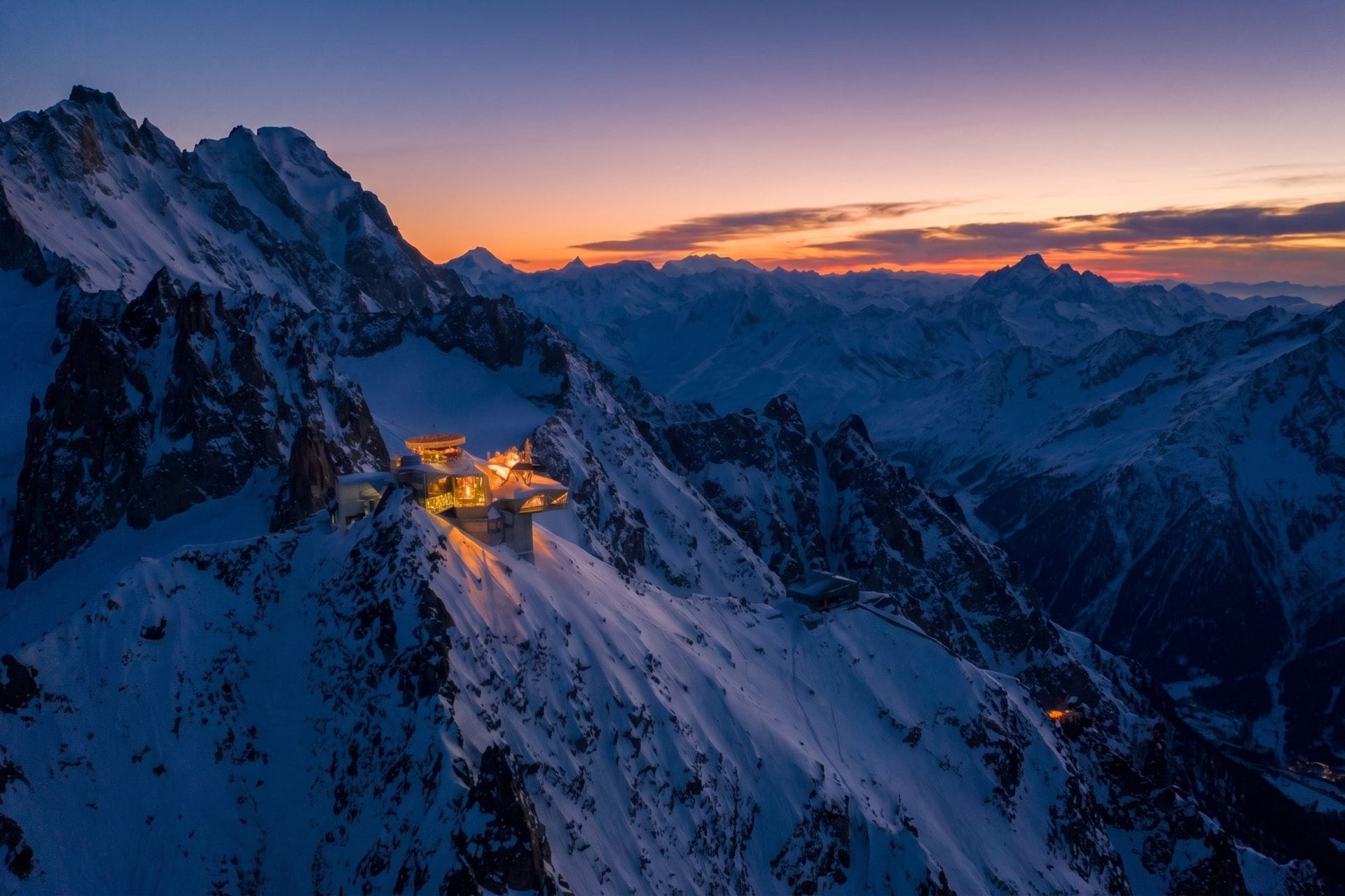
Opened in 2015, Skyway Monte Bianco climbs from Pontal, near Entrèves, at 1,300 meters, to Pavillon du Mont Fréty at 2,173 meters, and on to Punta Helbronner at 3,466 meters, the highest point reachable on the Italian side of the mountain without a rope. Its cabins rotate a full turn during the ascent, so the massif comes around the glass as the cable rises. At the middle station the Saussurea alpine garden, the highest botanical garden in Europe, holds several hundred high-altitude species through a growing season of only three months. The Skyway is a spectacle, and it has been argued against as one: conservation voices objected to the scale of the installation on a fragile glacial basin. What it offers a traveler who has come this far is a plain piece of geography delivered in twenty minutes, the sight from the summit terrace of the ground the guides have always climbed, and the widest view of Mont Blanc anywhere on the Italian side.
Hiking the trails above Courmayeur
In summer the ski resort turns into a walking town, and hiking is the plainest thing to do in Courmayeur. The lifts that carry skiers in winter run for walkers too, so a day can begin high, and from the top stations and the valley floors a web of balcony paths and old mule tracks climbs to the huts and the cols. Val Ferret and Val Veny carry most of what lies past the cable cars, and they are opposites.
Val Ferret and Rifugio Bonatti
Val Ferret is the quieter of the two. A balcony path climbs from the edge of town to Rifugio Bertone, at 1,989 meters, and continues along the valley wall to Rifugio Bonatti, at 2,025 meters, opened in 1998 and named, with his blessing and in his presence, for the alpinist Walter Bonatti. The hut sits on an open pasture directly across from the north faces of the Grandes Jorasses and the Fréboudze glacier, one of the set pieces of the Tour du Mont Blanc, which passes this way toward the Grand Col Ferret and Switzerland. The balcony between the two huts is the finest valley-level view of the massif on the Italian side, and the ridge of Mont de la Saxe above it carries the same view higher. In winter the valley floor turns to cross-country tracks, and the road up it is closed to traffic above Lavachey.
Val Veny and the Miage glacier
Val Veny is the wilder side. It holds Lac de Combal, a broad glacial flat of braided water and gravel below the Pyramides Calcaires, and above it Lago del Miage, a small lake pressed against the moraine of the Miage glacier, where blocks of ice have calved from the ice cliff into the water for more than two centuries. The road is seasonal, open in summer and served by a shuttle from La Visaille, and closed in winter; at the head of the valley the Col de la Seigne marks the crossing into France. The Miage glacier itself is of the Himalayan kind, buried under its own rockfall, so that the ice reads as stone until it moves.
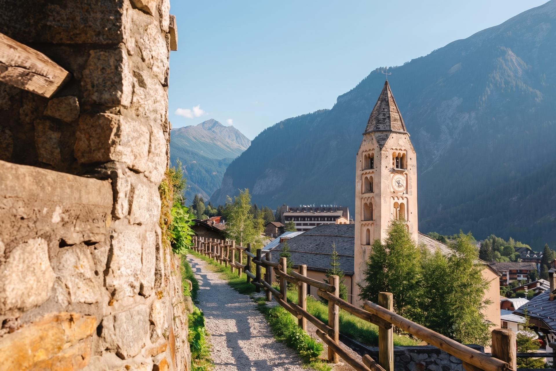
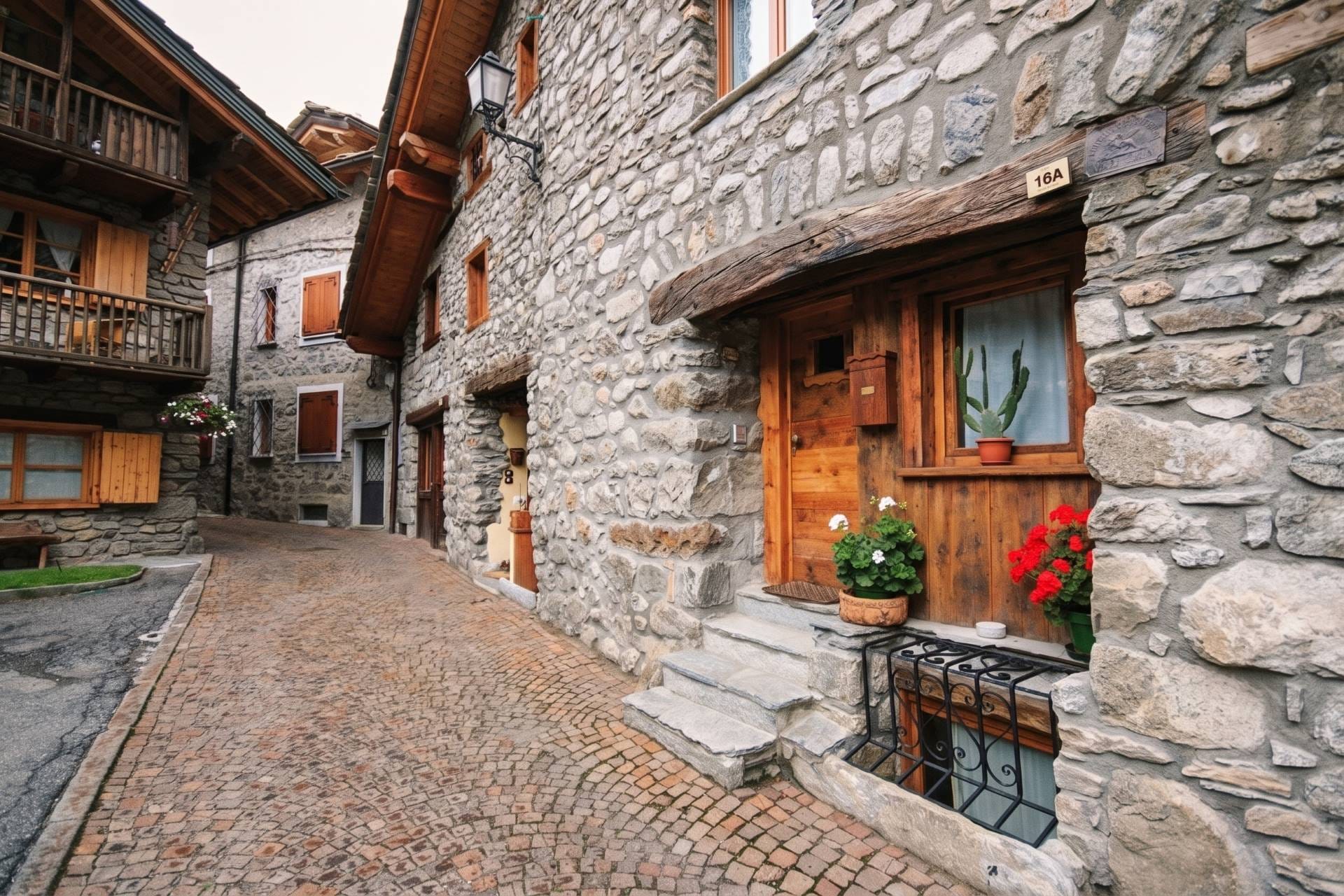
Via Roma and the old town of Courmayeur
Via Roma is the pedestrian spine of the old town, a stone street closed to cars, running between the church at one end and the town hall at the other. The parish church is dedicated to Saints Pantaleone and Valentino, and the old core grew up around it in stone. The window displays now run to skis and cashmere, but the shape of the street is older than the trade in it, and the Casa delle Guide stands along it as a reminder of what the town did before it sold anything.
The Museo Alpino Duca degli Abruzzi
Inside the Casa delle Guide, the Museo Alpino Duca degli Abruzzi holds the material record of the guiding society, renovated for the guides' hundred-and-fiftieth anniversary and again in recent years. Among the objects are the guides' logbooks, in which clients wrote up each ascent and, discreetly, the merits of the man who led it, alongside equipment from the Duke's expeditions. The museum is small and specific, which is the point: it is the profession's own archive, kept in the house the profession still uses.
The thermal baths at Pré-Saint-Didier
A short way down the valley, below Courmayeur proper, the thermal baths at Pré-Saint-Didier take the same spring water the aristocracy once came for. The water surfaces at around 37 degrees and has been known since Roman times; the present establishment traces to a nineteenth-century building. Run now by QC Terme, it opens a row of outdoor pools directly onto Mont Blanc, so the massif stands over the water in every season. It sits outside Courmayeur, in its own commune, which is worth knowing before counting it among the town's own sights.
Courmayeur off the beaten path
Climbing and alpine routes above Courmayeur
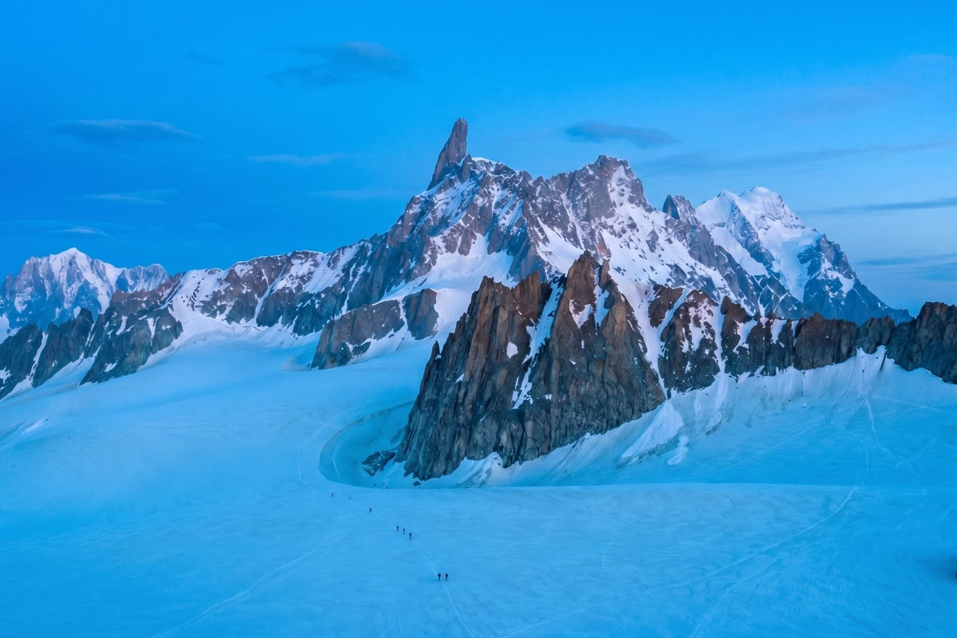
For those who came for the mountain itself, Courmayeur is one of the first addresses of alpinism in the Alps, and the ground above it holds some of the most storied climbing on the range. The granite spire of the Dente del Gigante and the long Rochefort ridge rise from the Géant glacier reached by the Skyway; the Aiguille Noire and the Peuterey ridge stand over Val Veny as one of the great routes to the summit of Mont Blanc; and lower down there is bolted crag and via ferrata for shorter days. This is serious terrain where the weather turns fast and the glaciers are live, so the routes are best done with a certified IFGMA / UIAGM local mountain guide, the profession the town has practiced since 1850 through the Società delle Guide Alpine di Courmayeur.
The Tour du Mont Blanc
The Tour du Mont Blanc is the great walk of the massif, a circuit of roughly 170 kilometers that rings Mont Blanc through Italy, France, and Switzerland. Because the route is a loop, it can be started from any point along it, and Courmayeur is the natural Italian base for the whole tour, one of the few points on the circuit with a real town rather than a hut, and easy to reach before the first day and to return to after the last. Most walkers take from a week to eleven days for the full loop, but the town also makes it possible to take the best of the Italian section in single days: the stage out of Val Ferret climbs to the Grand Col Ferret and the Swiss border, the stage out of Val Veny to the Col de la Seigne and the French one, each a day on the trail that returns to a bed and a table by evening. It is the walk the guides' successors grew up on, and the clearest way to understand why the two side valleys matter.
Entrèves, Dolonne and the villages around Courmayeur
Courmayeur is really a scatter of hamlets, the frazioni. Entrèves and La Palud stand at the Skyway base, where the two Doire of Ferret and Veny join to make the Dora; Dolonne sits across the water on the old side, its lanes narrow and stacked; and hamlets such as Villair climb the slope toward Val Ferret, half a step above the noise of the center. They are where the town keeps its ordinary life, and where the older stone survives without a shopfront in front of it.
Using Courmayeur as a base for the Aosta Valley
Given several days, Courmayeur works as well as a base as a destination, since the Aosta Valley is a fan of side valleys and the best of them lie within an easy drive. South of Aosta the three valleys of the Gran Paradiso, Valsavarenche, Val di Rhêmes, and Cogne, hold the oldest national park in Italy and the ibex it was created to save. East of the capital, Valtournenche climbs to Breuil-Cervinia under the Italian face of the Matterhorn, and farther east the Gressoney valley runs up toward Monte Rosa through Walser villages that still speak their own old German. Nearer at hand, La Thuile and the road to the Little St Bernard climb west toward France. Each is a day, and each is a different mountain.
Food and wine in Courmayeur
Food and wine in Courmayeur are Valdostan before they are Italian, closer to Savoy than to Rome, built for cold and for keeping. Fontina DOP, made in the alpeggi from the milk of Valdostana cattle, is the center of the table: melted with milk and egg yolks into fonduta, stirred through polenta concia, layered with bread and cabbage into the seupa à la vapelenentse. Beef comes braised slowly in red wine as carbonade, over polenta rather than pasta, since wheat never grew easily this high. The cured meats carry their places in their names: Jambon de Bosses DOP, aged at 1,600 meters, Lard d'Arnad DOP, and the dried mocetta.
A meal closes on génépy, the pale herbal liqueur that is the region's own. It is made from wild Artemisia, the small aromatic wormwood that grows on the high screes above the tree line, gathered by hand in summer and steeped in spirit with a little sugar; the taste is bitter, resinous, and faintly sweet, and it is drunk cold as a digestivo. The plant is now protected and its picking regulated, which is part of why a good génépy reads more as a mountain artifact than as an ordinary bottle. The other way to end a meal is caffè alla valdostana, coffee laced with grappa, génépy, and citrus, lit at the table and passed from spout to spout around the coppa dell'amicizia, the multi-spouted friendship cup that no one sets down until it is empty. The ritual is the point of it as much as the drink.
The wine is Blanc de Morgex et de La Salle, grown just down the valley at Morgex from prié blanc, a white grape found almost nowhere else. Its vines are ungrafted, propagated as they were before phylloxera because the pest cannot complete its cycle at this altitude, and they sit on low pergolas between roughly 900 and 1,200 meters, among the highest vineyards in Europe. The wine is dry, taut, and mineral, the taste of the slope it grows on.
For a table with some history, the Maison de Filippo at Entrèves has served the valley's cooking since 1965. The region's Michelin stars sit lower down, toward Morgex and Aosta; Courmayeur's own kitchens keep closer to the tradition, which is the better argument for eating in them.
Where the ice begins
The town is a threshold. Everything in Courmayeur points up the valley to the place where the road, the vines, the language, and the country itself give out and the ice takes over. The guides have been walking across that line since 1850, and the cable car now carries the rest of us partway toward it in glass. In summer the walkers take the older way, out along the balcony paths and up toward the cols, and come back down in the evening to a town that has kept its measure. Either way the mountain is the same, standing white over a small town at the head of Italy, indifferent and near. It rewards the slow visit, the several days that let the valleys and the table do their work, and it is the last thing anyone remembers of the place: not the shops on Via Roma but the light on Mont Blanc after the sun has left the street.
Practical information
Guide to Italy is a letter from an Italy that doesn't write to everyone.
Become a member


